
When you read any book on military history, you quickly learn that salients are BAD. What on earth, then, was the Roman emperor Trajan thinking when he annexed the province of Dacia in AD 106? Two books I read recently touch on this issue and come to very different conclusions.
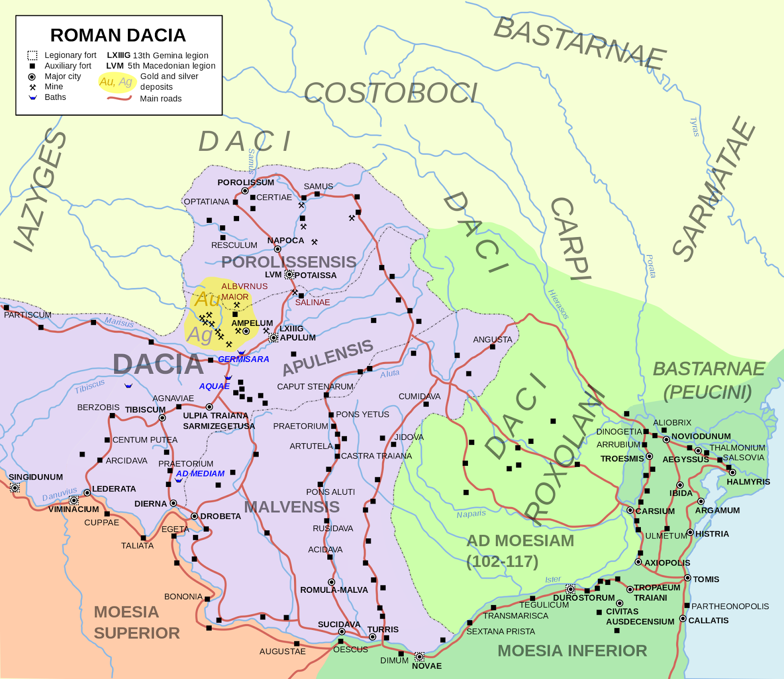
Seen on a modern map (shown at the top, in purple), the Roman province of Dacia looks like a textbook example of an exposed salient. The boundary of the Roman empire had until then extended east-west across the Balkan Peninsula with the Danube as the northern border. The new province jutted awkwardly north of the river, inviting trouble. As Edward N. Luttwak explains in his wonderful book The Grand Strategy of the Roman Empire From the First Century A.D. to the Third:
[T]he frontiers of the new province of Dacia formed a deep wedge . . . adding more than 370 miles to the length of the imperial perimeter. In fact, on the map the new province presents a classic profile of vulnerability.
And yet, Luttwak argues that Dacia made sense, at least so long as the Romans had sufficient military strength. This is because the salient effectively separated two groups of tribes, one situated on the western side of the salient, the other on the eastern, impeding their ability to coordinate attacks:
On either side of the Dacian salient were the plains occupied by the subsidized Sarmatians: Iazyges to the west and Roxolani to the east. Had Rome been weak and the Sarmatians strong, the Dacian province would have been vulnerable to encirclement . . .; but with Rome as strong as it then was, the Dacian frontier effectively separated the Sarmatians on either side and weakened their combined power.

I know it's a far-fetched analogy, but on a far smaller scale Robert E. Lee's troop disposition at the North Anna River during the Overland Campaign immediately came to mind. By establishing a position with a salient, Lee effectively impeded the ability of the Union forces to coordinate their attacks on the two sides of the salient.
In her equally fine book Rome and the Enemy: Imperial Strategy in the Principate, on the other hand, Susan P. Mattern wonders whether Trajan even understood that he was creating a salient. As I discussed in this recent post, the ability of the Romans to visualize geography was poor to nonexistent. Citing maps such as these reconstructions of Strabo's and Ptolemy's maps of Europe , together with evidence that the Romans thought that the entire distance from the Danube to the North Ocean was fewer than 400 miles, Prof. Mattern suggests that Trajan may well have imagined the territory as having a shape far different than the one we see on a modern map:

But it is not clear that Trajan and his advisers thought of strategy in terms of two-dimensional geography at all; or if they did, the vulnerable salient evident to modern cartography was not necessarily what they imagined. For example, Ptolemy's work . . . shows the Carpathian Mountains running east to west in a straight line . . .. Dacia, on Ptolemy's map, looks very different and more "rational" than on a modern one.

Indeed, Trajan may have expected that the northern boundary of the territory would be the Northern Ocean itself, eliminating any salient altogether:
But the most likely frontier imagined by Trajan when he invaded this territory was the ocean itself. It is likely that he shared the prevalent view of a flattened northern Europe; Agrippa had, after all, placed the ocean only 396 miles from the Danube River. The total conquest of eastern Europe must have seemed an attainable goal. . . . [B]ecause of the mainly mythological nature of Roman conceptions about the area, it seems probable that the emperor was motivated by notions of reaching the northern ocean and the exciting prospect of exploring and conquering exotic, unknown territory, which was also supposed to be rich in gold.


No comments:
Post a Comment